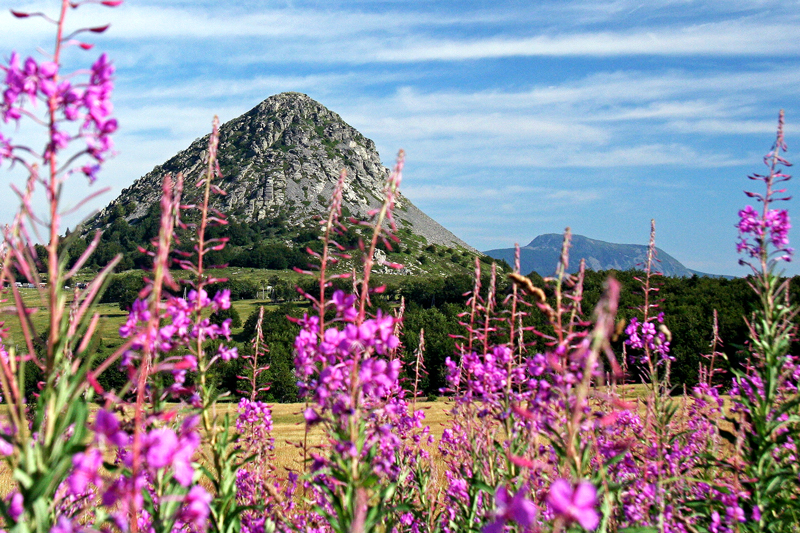
Gerbier de Jonc and the Loire sources
The Loire's source is in the Mont Gerbier de Jonc... For French people, this sentence brings back memories of their school days. For those who will not feel this nostalgia, a tour of the Gerbier will bring a kind of fulfilment one can only experience when one discovers for the first time unique landscapes. Because, yes, you are here at the heart of the biggest phonolitic range in Europe. This characteristic is not a scientific fact only, it appears in the landscape with this incredible set of volcanic peaks rising from the Boutières Valleys. The most famous of them, the Gerbier, is impressive, 150 m above the plateau and the visitors at its base. Climbing it is a unique experience. The discovery of the sources at its foot offers a pleasant complement to the walk after the climb, and one is always amazed to realize that the Loire, this grand and powerful river, is at birth just a modest rivulet.
Description
- From the parking lot, go to the first source : "l'authentique". In fact, it is a building erected in 1938 by the Touring Club de France, as a symbol of the Loire's source.
- From there, take the stairs up to the site house. The path to the top starts on the right of the building. After a few meters, turn right again to begin the climb. Follow carefully the markings and stay on the path up to the summit.
- Once there, enjoy the view. To go down, take the path starting on the opposite side from the one you came on. Be careful on your way. A few ropes are there to help you when the slope is too steep.
- Once at the foot of the Gerbier, go to the picnic area and the Gerbier de Jonc bar-restaurant. Cross the road and find the board "sentier des sources". From there, follow the path marked by blue circles on the ground. You will first cross a wood and then reach the road (D116). Cross it and follow the narrow road on the left between grassy paths. Follow it for 600 m then take the path on your left and enter the woods (still following the blue circles). You will walk along one of the three streams that form the Loire at its beginnings, before entering a pasture (don't forget to close the gate after you). At last, you have reached...
- beside a small pond, the "véritable" Loire source. Notice the board saying "ici commence ma course vers l'ocean" (Here starts my run to the ocean). The "véritable" source is the official one farthest from the Loire's mouth.
- Go back to the road, then turn left towards the Gerbier, still following the markings. After 400 m, carry on straight ahead at the intersections with the roads D327 and D116.
- 150 m after the intersection, you will find a wide track on the right going down towards the Flotte farm.
- After 300 m, you will be able to discover the sight apparatus enabling you to visualize the water divide line in the landscape. Then go back to the parking lot by the same way.
- Take the path on the left towards the farm building with a flagstone roof "La source de la Loire" where you will find the third and last source of the path. This "géographique" source runs into a stone basin, at the entrance to the stables. It's amazing to think that this small rivulet will later give birth to a large river. From the farm, take the stairs back up to reach the "authentique" source and the site house, your starting point.
- Departure : Gerbier de Jonc site house in Sainte-Eulalie.
- Arrival : Gerbier de Jonc site house, in Sainte-Eulalie
- Towns crossed : SAINT-MARTIAL and SAINTE-EULALIE
Forecast
Altimetric profile
Sensitive areas
Espace Naturel Sensible (ENS) Gerbier Mézenc
Merci de bien vouloir rester sur les sentiers aménager afin de ne pas déranger la faune ni piétiner la flore.
- Impacted practices:
- All practices
- Contact:
Natura 2000 Secteurs des sucs Gerbier et Mézenc
Merci de bien vouloir rester sur les sentiers aménager afin de ne pas déranger la faune ni piétiner la flore.
- Impacted practices:
- All practices
- Contact:
Recommandations
La montée au sommet du Gerbier peut présenter quelques difficultés pour ceux qui ont des soucis physiques ou des problèmes de vertige. Dans ce cas, préférez le sentier des sources, très accessible.
Access and parking
From Privas, take the road D378, also called "route des paysages" (landscapes road) because it offers lots of beautiful sights and belvederes on the Boutières and the Haute Cévenne on each side.
Parking :
Report a problem or an error
If you have found an error on this page or if you have noticed any problems during your hike, please report them to us here: