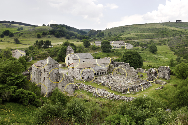
Abbey of Mazan
SAINT-CIRGUES-EN-MONTAGNE
Abbey of Mazan
Hard
6h30
19,3km
+468m
-468m
Loop
Embed this item to access it offline
The abbey of Mazan holds a very high place in the Monts d'Ardèche heritage. Since 2017, it has been host to one of the major pieces of art of the Water Divide : Un Cercle et mille fragments by Felice Varini. Beyond the work, impressive whatever the weather or season, the trek that starts at Saint-Cirgues-en-Montagne and goes above the Roux tunnel presents all the plateau's landscapes and environments : low mountain range forests, moorland, hayfields... An immersion in nature and contemporary art !
Description
1. From the village of Saint-Cirgues-en-Montagne, take the road to Le Roux/ Montpezat. At the bridge, turn right on the path that goes downhill along the river, and uphill again towards a secondary road. Follow it up to the Eperon (riding school), then towards Lalligier.
2. When coming to a mound, take the direction of Mazan (6.2km) pointed out on the pole marker.
3. Once you reach a narrower road, take the tarmacked cul-de-sac (road sign) that becomes a path going down towards the river.
4. Ford the river (the ford can be treacherous in times of flood). At the Sagnas crossways, take the direction of "La Chavade". Go uphill on the path into a beech and pine wood. The path goes downhill again towards a wood footbridge and up along a row of beech trees to the Fontbonne farm.
5. Skirt the farmhouse to the right and take the road going uphill. Then turn left on the path uphill along the power line. You will come to a first road. At the place called "Les Palles", turn left up to the hike pole marker and follow the road (don't take the path in the embankment on your right). You will come to a pole marker at the place called la Maison forestière de Bèque, that you can see below on your left.
6. At this crossways, take the track on your right towards "Mazan, 3.7 km". Follow the red and yellow markings (Tour de la Montagne Ardéchoise). When arriving to a large track, take the PR (short-distance path) in front of you towards "Mazan, 2.6 km".
7. Once you come up to the pole marker "Ruisseau de Mazan", take the forest track on your right "Mazan, 2.2 km" and follow it up to a road.
8. Take this road on your right to the village of Mazan-l'Abbaye. Go to the viewpoint on the artwork after the city hall's technical house, on your left. Retrace your steps back to the abbey, on the road that goes down steeply. You can visit the abbey at leisure, then go uphill again on the road to the inn above. Take the road behind the inn, following the "Tour de Pays" markings (red and yellow).
9. After 1 km, take the firemen track (DFCI) on your right (yellow and red markings). Go up the track until you come to a large cistern, then take the direction of Saint-Cirgues on your right.
10. You will go downhill on a path for about 4 km towards a concrete footbridge crossing the river. Take the path on your left uphill and again the path going along the river behind the houses towards the bridge of Saint-Cirgues-en-Montagne.
- Departure : The bridge at the entrance of Saint-Cirgues-en-Montagne
- Towns crossed : SAINT-CIRGUES-EN-MONTAGNE, MAZAN-L'ABBAYE, and LE ROUX
Forecast
Altimetric profile
Sensitive areas
Along your trek, you will go through sensitive areas related to the presence of a specific species or environment. In these areas, an appropriate behaviour allows to contribute to their preservation. For detailed information, specific forms are accessible for each area.
Recommandations
Randonnée sans difficulté particulière mais longue, pour marcheur averti.
Access and parking
Road linking Montpezat-sous-Bauzon to Saint-Cirgues-en-Montagne through the Roux tunnel.
Parking :
Dans le village de Saint Cirgues en Montagne
Report a problem or an error
If you have found an error on this page or if you have noticed any problems during your hike, please report them to us here: