Chemin du partage (Water Divide Path)
USCLADES-ET-RIEUTORD
Chemin du partage (Water Divide Path)
Medium
3h30
8,3km
+339m
-339m
Loop
Embed this item to access it offline
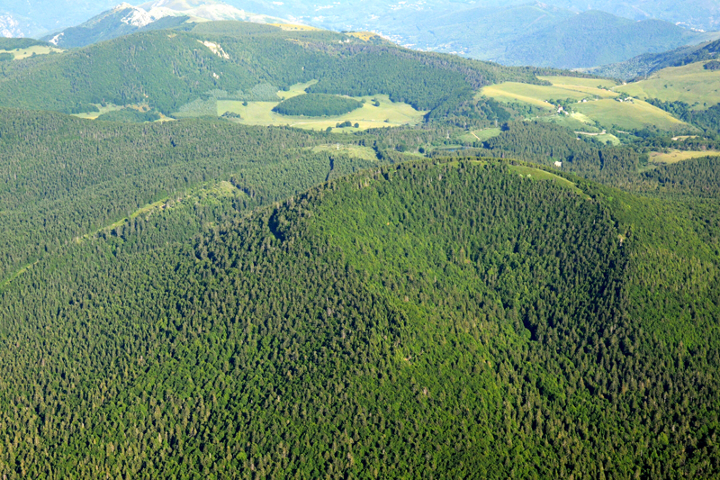
The chemin du partage (Water Divide Path) is an interpretive path offering a historical jaunt in a natural environment, the gorgeous and amazing forest of Bauzon, where the famed water divide between the Atlantic Ocean and the Mediterranean sea passes. This hike, suited to a family outing, allows young and old to break free for a half-day, to get to know a little what life was like in the past on the Ardèche plateau, and to climb the Suc de Bauzon's volcano. This hike is made of a loop and a return trip to the top of the Suc, offering a wonderful sight on the high Loire Valley, a landscape that has remained virtually unchanged for centuries. Through this 4 hours walk , you will discover parts of the local history and heritage. You will only have to let yourself be led by the various facilities explaining several episodes of Usclades et Rieutord's history. Then your mind and imagination will be able to take over. From one interpretive board to the next, the villages' life and history, outstanding characters and local legends will be evoked. And also the great works that have marked and still mark the Ardèche Mountain and its landscape.
Description
- Take the path on the right of the shed. After about 150 m, cross the footbridge. You will reach a road.
- Follow it on the right. The tarmac disappears and it becomes a track following the road above it. (Red and yellow GR (long-distance path) de pays markings).
- After 400 m, the track splits up (board n°13: 100 m sous Terre). Take the narrow path on the left into the beech woods. After the woods, pass two gates that lead you to a secondary road. Take the goat track in front of you, under the beech tree.
- On coming to another secondary road, follow it on your right for 50 m, then turn left at the pole marking (place called Cornillon) in the direction of "Rieutord, Suc de Bauzon, 3.3 km".
- When the path splits up, take the larger one (yellow and white markings). After 500 m in the undergrowth, you will reach a road under big fir trees.
- Take the path going steeply uphill in front of you and follow it, straight ahead, into the forest. When you come to board n°9 (la forêt sinistre), you will see a very big beech tree overlooking the path. Continue on this path, past board n° 11 (la forêt enchanteresse).
- After 200 m, turn right on the path making a hairpin bend to reach the summit (40 mn for the return trip).
- At the top, you will find a beautiful clearing (landscaping trees felling in the forest) and an interpretive board explaining the peculiar situation of this summit, shared by several villages. (accord au sommet, board n° 10). Back to the crossways (step 7) that took you to the summit, take the path on your right up to a large forest crossways.
- Turn left on the GR7 (direction Rieutord, 1.6 km). Crash course in geography : a board explains the "ligne de partage des eaux".
- Follow the GR7 on the grassy track on your left. It continues straight ahead under the trees and leads to a large clearing. Go down along the power line towards the little summits in the distance.
- The track turns right under the power line and leads to an art installation, a throne made of volcanic stones (n°5 le roi des forêts). Continue on this path that goes downhill rather steeply up to the interpretive board n°4 (2 villages, 1 commune).
- At the pole marker, take the path that goes down to the village (on the left)... follow the road for 400 m, back to the narrow path underneath the road that will lead you to the parking lot.
- Departure : Booth "Sentier du Partage" with an information board about the hike, in Rieutord
- Arrival : Abri «Sentier du partage», parking Rieutord
- Towns crossed : USCLADES-ET-RIEUTORD, MONTPEZAT-SOUS-BAUZON, CROS-DE-GEORAND, and SAINT-CIRGUES-EN-MONTAGNE
Forecast
Altimetric profile
Sensitive areas
Along your trek, you will go through sensitive areas related to the presence of a specific species or environment. In these areas, an appropriate behaviour allows to contribute to their preservation. For detailed information, specific forms are accessible for each area.
Recommandations
Privilégiez une progression dans le sens inverse des aiguilles d'une montre (comme ici décrit). La balade sera alors plus facile.
Access and parking
From Sainte-Eulalie, take the road D116 along the Loire River. At the intersection with the road D536, take the direction of Rieutord.
Parking :
À l’entrée de Rieutord, parking à droite en venant de Sainte-Eulalie (au pied du relais électrique).
Report a problem or an error
If you have found an error on this page or if you have noticed any problems during your hike, please report them to us here: