Gruas Ridge
SAINT-VINCENT-DE-DURFORT
Gruas Ridge
Medium
3h
8,2km
+284m
-295m
Loop
Embed this item to access it offline
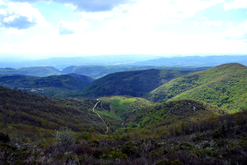
At the Northeastern tip of the Monts d'Ardèche Park, the villages of Saint-Vincent-de-Durfort and Saint-Cierge-la-Serre possess a jewel perched at an altitude of more than 800 m : the Gruas ridge, veritable balcony on the Rhône Valley and the Alps. This walk offers beautiful sights on the Ouvèze, Eyrieux and Rhône valleys. Close to and at the same time out of the main Rhône Valley's highways, the Gruas ridge, with its unspoilt wilderness, will delight those who love rugged landscapes.
Description
- Turn right on the road going uphill to "Serre de Gruas, 0.9 km, Saint-Cierge-la-Serre, 4.7 km". Once at the hamlet, go through it and continue towards the top of the ridge.
- At the crossways, a Geopark totem pole will point out the geological peculiarity of this site. Take the path on the right and cross the barrier (don't forget to close it after you). At the next crossways, stay on the right. After a few hundred meters, with beautiful sights on the Alps and the Ouvèze, you will reach the crest line with a 360-degree view on a large part of the Alps range, the Mézenc-Gerbier range, and the Ouvèze Valley. Once at the cairn, the path starts going downhill on your left.
- At the Goulet-la-Verrière crossways, take the path going downhill on the right towards "Saint-Cierge-la-Serre, 2.3 km"
- Once at the crossways, carry on straight ahead.
- At the Croix pass, turn right towards "Le Pigeonnier, 6.1 km, Flaviac, 9.9 km". You will then stay on the path on the left going downhill along meadows, and later along a chesnut grove.
- At the crossways overlooking the hamlet, take the path on the left towards the hamlet, where you will follow the markings carefully.
- At the Aurelle crossways, turn right on the road going uphill towards "Les Croix de Gruas, 3.3 km, Serre de Gruas, 4.1 km" At the La Coste intersection, go right.
- At the end of the road, take the rightmost path, uphill. A few meters later, stay on the path going uphill on the right. At the next crossways, stay on the main path going straight ahead. It will then wind along a gentle slope in the woods up to the Serre-du-Pré crossroads.
- From there, continue straight ahead in the direction of "Les Croix de Gruas, 0.6 km, Serre de Gruas, 1.4 km" After 500 m, at the intersection, go right (you will see the fire cistern) back to the Croix de Gruas crossroads, your starting point.
- Departure : Take the road on the right going uphill towards "Serre de Gruas 0.9 km, Saint-Cierge-la-Serre 4.7 km"
- Towns crossed : SAINT-VINCENT-DE-DURFORT and SAINT-CIERGE-LA-SERRE
Forecast
Altimetric profile
Recommandations
Attention, vous allez traverser des propriétés privées dans un environnement préservé. Merci de bien vouloir y être attentif.
Access and parking
From Privas, take the direction of Les Ollières, up to Le Chambon-de-Bavas, then turn right towards "Saint-Cierge-la-Serre. At Vareilles, turn right towards "Gruas, hameau de Gruas" . The narrow road goes quite steeply uphill for 2.5 km.
Parking :
Carrefour des croix de Gruas, face à la réserve à incendie.
Report a problem or an error
If you have found an error on this page or if you have noticed any problems during your hike, please report them to us here: