La Jaubernie caves
COUX
La Jaubernie caves
Medium
2h
4,8km
+219m
-217m
Loop
Embed this item to access it offline
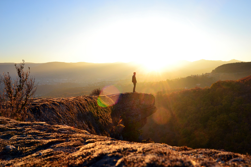
Close to Privas, Coux is the first remarkable village when you enter the Monts d'Ardèche Natural Regional Park through the Ouvèze Valley. This walk will take you from the Ouvèze banks to the dramatic site of La Jaubernie's fortified cave dwellings, sheltered under a huge sandstone slab. Apart from the caves, the slab above them offers beautiful sights on Privas and the Ouvèze Valley, especially in the late afternoon, when the sun sets the sandstone ablaze.
Description
- Take the pedestrian crossing. Once on the pavement, turn left, then immediately right after 5 m, under the porch and up the stairs.
- At the top of the stairs, take the road on the left towards "Vieux village, 2 km - La Croix, 1.4 km".
- After 50 m, take the path going uphill on your right towards "La Jaubernie, 1.4 km - les grottes, 1.8 km".
- The cobblestone path soon takes you to the narrow road leading to the hamlet of La Jaubernie (white and yellow markings).
- Once at the hamlet, at the crossways, carry on straight ahead towards "Les grottes, 0.4 km - Coux, 2.5 km". Skirt the houses then go uphill on your left, on the road. Follow it for 400 m up to a rocky plateau.
- From there, leave the road to reach the caves crossways. Turn left towards "Grottes de La Jaubernie" and follow the cobblestone path that will then turn right, going up between box trees along the cliff.
- Be cautious : you must follow the cliff to reach the first caves. After them, a winding and steep path in the undergrowth will lead you to the top of the slab. Midway on your right, you will find a last fortified cave. At the top of the slab, behind the hike marking pole, is a strange "throne" carved into the rock (a sit and a spot for your feet). Do not hesitate to try it.
- Go right in the direction of "Les grottes, 0.3 km - Coux, 2.4 km". The slab you are now crossing was used as a millstone quarry, see the traces left in the rock by the carving out of the stones. Cross this large slab in front of the Ouvèze Valley and Privas. Then carry on straight ahead to get back to the caves crossways.
- This time, turn left towards "Coux, 2.1 km" and follow the path going downhill (chemin d'Aureac) and past an old dovecote.
- Just before the next house, turn right towards "La Charrière" and pass the gate (don't forget to close it after you). Follow the path up to the hamlet.
- At La Charrière hamlet, continue on the road going slightly to the right.
- Follow it for 800 m up to the intersection with the road going up to La Jaubernie. There, turn left up to the first crossways where you will turn left again to come back to your starting point.
- Departure : Hike board on d'Onclaire square, Coux
- Towns crossed : COUX
Forecast
Altimetric profile
Recommandations
Attention, les grottes de la Jaubernie sont des propriétés privées, admirez-les depuis le sentier. Le sentier passe en bord de falaise, la balade est donc déconseillée aux personnes souffrant de vertige.
Access and parking
From the Rhône Valley, take the road D104 in the direction of Privas and stop at Coux.
From Privas, take the same road in the direction of Valence and stop at Coux, on d'Onclaire Square.
From Privas, take the same road in the direction of Valence and stop at Coux, on d'Onclaire Square.
Parking :
place d’Onclaire, en bord de la D104 à côté de l’arrêt de car, Coux
Report a problem or an error
If you have found an error on this page or if you have noticed any problems during your hike, please report them to us here: