Chaudeyrolles narces
CHAUDEYROLLES
Chaudeyrolles narces
Easy
1h30
4,6km
+78m
-74m
Loop
Embed this item to access it offline
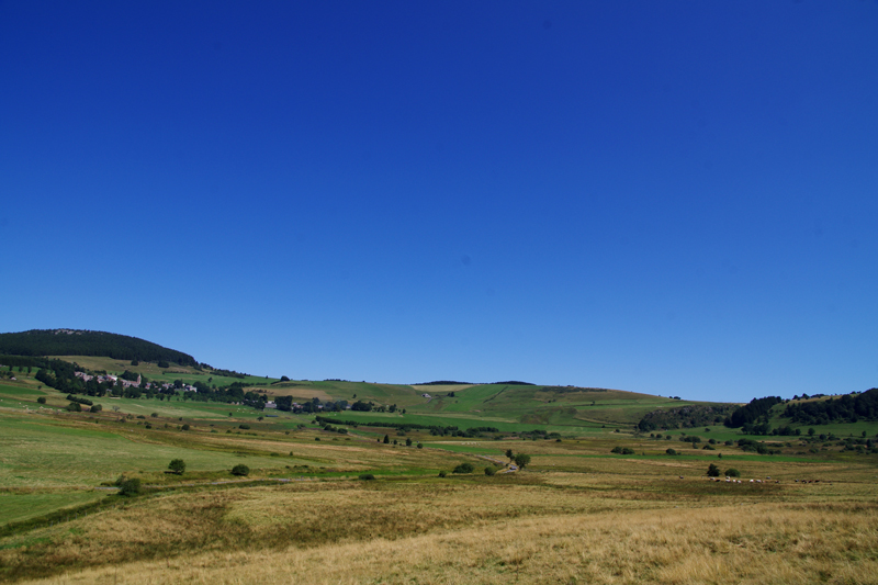
The Monts Mézenc and Signon frame beautifully this walk which will lead you to the heart of the maar crater of Chaudeyrolles. But you will have to climb (Mont Signon, for instance) to really see the crater's shape. The narces, very fertile wet lands constituting an agricultural heritage still very much alive, are in the old crater. Waterfall, brook, flowers, farms, woods and stunning panoramas accompany this walk glorifying life in all its forms.
Description
- Take the path going downhill on the left across the last cluster of houses of Chaudeyrolles. Past them, you will reach a tarmacked road.
- Take it on the left, without paying attention to the paths on each side. Enjoy the view on the narces, with Mont Mézenc in the background and a gorgeous waterfall that you will see lower. If the wind is kind you will also see paragliders flying from the North top of the Mézenc. Continue on the road; after a few dozen meters, a first interpretive board describes the landscape. Walk up to the cross.
- From there, turn right. the road goes into the narces towards Mont Mézenc (feather markings). Soon, a second board will explain the geological formation of the site. You will then cross the Salin brook, with the waterfall of the same name in the background. A board will give you details about the Lignon fauna. Continue on the tarmacked road; Mont Signon, that you can now see quite clearly, is behind you. On your right, two other interpretive boards will tell you more about the narces and peat. Go towards the big stone house. After it, the tarmac disappears and the path makes a bend along woods. Don't pay attention to the path that will turn left after 300 m. Enjoy the one shaded part of the walk and the nice views on Chaudeyrolles, at the foot of Mont Signon. At the end of the woods, you will see a small scree on your right. Continue on the road up to the big stone building. You are on tarmac again. Don't take the path going uphill on your left.
- Stop paying attention to the VTT markings, go right and stay on the tarmacked road going back towards the village.
- Cross the brook. At the crossways, take the road on the right, the quickest to the village. It crosses the heart of the narces.
- Once back at the cluster of houses of step 1, turn left towards the village.
- From the church, go right on the road D274, downhill, that will lead you back to the parking lot.
- Departure : Parking lot with a Geo totem pole on the road D274 in the South of Chaudeyrolles
- Towns crossed : CHAUDEYROLLES
Forecast
Altimetric profile
Sensitive areas
Along your trek, you will go through sensitive areas related to the presence of a specific species or environment. In these areas, an appropriate behaviour allows to contribute to their preservation. For detailed information, specific forms are accessible for each area.
Natura 2000 et ENS Secteurs des Sucs Gerbier et Mézenc
- Impacted practices:
- All practices
- Contact:
Recommandations
Il n’y a pas de points d’eau sur le parcours. Le sentier est très rarement ombragé, soyez prévoyants par fortes chaleurs. Le sentier emprunte en partie le circuit VTT, et, tout au long du parcours, vous trouverez un balisage avec des plumes.
Access and parking
From Les Estables, go East on the road D631, then take the D274 up to Chaudeyrolles. Watch out : the road is closed during the long winter period and can still be icy in places in the spring. In that case, take the road D36, then turn right on the D500. After Le Bouchet Haut, turn right on the D274.
From the North, go through Fay-sur-Lignon and follow the D500 until it crosses the D274 that will lead you to the village.
From the North, go through Fay-sur-Lignon and follow the D500 until it crosses the D274 that will lead you to the village.
Parking :
Avant le village de Chaudeyrolles, si vous venez du Sud, sur la D274, un parking avec un géototem marque le départ du sentier.
Report a problem or an error
If you have found an error on this page or if you have noticed any problems during your hike, please report them to us here: