Boutières Cirque
LES ESTABLES
Boutières Cirque
Medium
3h15
12,2km
+315m
-296m
Loop
GRP
PR
Embed this item to access it offline
This hike goes around the Mont Mézenc via the Boutières Cirque and offers landscapes among the most beautiful in the Massif Central, from the summit as from the Boutières Cross. If the climb is well frequented, it becomes far less busy as soon as you pass the Boutières Cross towards Medille, while still offering grand landscapes that will delight nature lovers. This decidedly mountainous walk will amaze you by the dramatic variety of the landscapes you will go through on the Haute-Loire side (high plateau) and on the Ardèche side (very steep and rugged).
Description
- From the Peccata Cross parking lot, take the track going uphill towards the Mézenc. After 1 km, leave the track to follow a narrower path on the left, into the woods. The path goes up more and more steeply up to a crossways, from where you can see the two Mézenc summits.
- From there, you can make a return trip to the two summits. Going back to the crossways, take the path on your left, back towards the forest. It goes downhill among conifers to the Boutières parking lot.
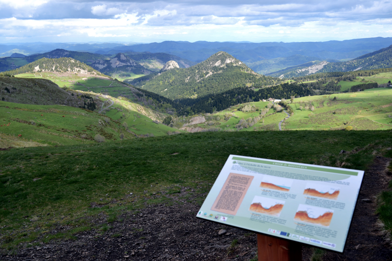
- From the Boutières parking lot, you can reach the Boutières Cirque interpretive board by a return trip on the GR (long-distance path) going uphill in the forest.
- After about 500 m, you will find on your left the interpretive board above the Boutières Cirque. Back to the parking lot, take the road going downhill on your right towards the Cirque.
- After 60 m, take the wider path on the left. After 1.5 km, at the crossways, go straight ahead. The path goes down rather steeply at times, and leads to the "route touristique du Mézenc".
- Take it on the left for about 1.5 km.
- Once you reach the meadow along the Medille farm, take the path on the left, in the meadow, to reach a crossways.
- Turn right, and then left towards the forest. You will go through a peat bog. Once you reach an intersection, take the path on the left, perpendicular to the one you came on.
- You will meander in the forest, find another peat bog then overlook rocks, and then reach a large track fairly straight. It will lead you back to the Peccata Cross parking lot.
- Departure : Peccata Cross, road D400, Les Estables
- Arrival : Peccata Cross, road D400, Les Estables
- Towns crossed : LES ESTABLES, BOREE, LA ROCHETTE, and CHAUDEYROLLES
Forecast
Altimetric profile
Sensitive areas
Along your trek, you will go through sensitive areas related to the presence of a specific species or environment. In these areas, an appropriate behaviour allows to contribute to their preservation. For detailed information, specific forms are accessible for each area.
Espace Naturel Sensible (ENS) Gerbier Mézenc
Les ENS ou Espace Naturel Sensible sont une politique du Département qui vise à préserver la faune, la flore, la géologie et les paysages remarquables du Département tout en conciliant l'accueil du public. L'ENS mont Gerbier et Mézenc se caractérise par ses paysages de montagne où alternent, praires, landes, zones humides et forêts.
Merci de bien vouloir rester sur les sentiers aménager afin de ne pas déranger la faune ni piétiner la flore.
Merci de bien vouloir rester sur les sentiers aménager afin de ne pas déranger la faune ni piétiner la flore.
- Impacted practices:
- All practices
- Contact:
Natura 2000 Secteurs des sucs Gerbier et Mézenc
Natura 2000 est une politique Européenne dont l'objectif est de préserver la biodiversité à l'échelle de l'Europe. Avec ses presque 30 000 sites reconnus, il est aujourd'hui le plus grand réseau de sites naturels au monde. Le site que vous traversez à pour but de préserver les landes du Mézenc qui abritent une faune et une flore rare à l’échelle Européenne.
Merci de bien vouloir rester sur les sentiers aménager afin de ne pas déranger la faune ni piétiner la flore.
Merci de bien vouloir rester sur les sentiers aménager afin de ne pas déranger la faune ni piétiner la flore.
- Impacted practices:
- All practices
- Contact:
Natura 2000 et ENS Secteurs des Sucs Gerbier et Mézenc
- Impacted practices:
- All practices
- Contact:
Réserve biologique dirigée du Mézenc
Les réserves biologiques ont pour objectif la protection et la gestion conservatoire d'habitats naturels remarquables et/ou d'espèces rares et menacées. Elles sont créées uniquement sur les espaces relevant du régime forestier. C’est-à-dire, les forêts de l'Etat (domaniales) ou les forêts des collectivités (communes, départements…). Elles sont gérés par l'Office National des Forêts.
Merci de bien vouloir rester sur les sentiers aménager afin de ne pas déranger la faune ni piétiner la flore.
Merci de bien vouloir rester sur les sentiers aménager afin de ne pas déranger la faune ni piétiner la flore.
- Impacted practices:
- All practices
- Contact:
Recommandations
Itinéraires de montagne avec quelques passages techniques. Soyez vigilant vis-à-vis de la météo. Pour faire l’aller-retour au sommet du Mézenc, rajouter 45 min.
Access and parking
From Les Estables, take the forest road D274 towards Chaudeyrolles (closed in winter).
Parking :
Parking de la Croix de Peccata D274, Les Estables
Report a problem or an error
If you have found an error on this page or if you have noticed any problems during your hike, please report them to us here: