Echamps plateau
BOREE
Echamps plateau
Easy
2h
6,7km
+147m
-148m
Loop
PR
Embed this item to access it offline
At the heart of the phonolitic Mézenc-Gerbier range, the Sara Suc is a prize for the deserving, but one never regrets the climb. Clearly visible in the landscape, its triangular shape is puzzling with this long and very thin crest line that looks as if it rose from the bottom of the Eysse Valley to reach the summit. Well, this ridge, which doesn't exceed 1 m in width in places, is the only access to the top. A hike, therefore, only for those who are not afraid of heights. From up there, the 360-degree view will reward your effort. From the top, the wild nature of the High Boutières is fully revealed ; everywhere you see mountains, forests, steep valleys and unspoilt landscapes. Traces of human activity are sparse. A true disconnection.
Description
- From the main square, take the road D378 down below in the direction of Chaneac (or Echamps, 2.4 km - Saint-Martial, 6.7 km). Just after that, follow the road on the left towards "Echamps, 2.4 km, Saint-Martial, 6.7 km".
- When going out of Borée, take the path on the right towards "Saint-Martial, 6.5 km". After 100 m, at the crossways, continue straight ahead. The path then goes uphill rather steeply up to the road.
- Turn right towards the Virgin Mary and the Tchier. Do not hesitate to wander in the monumental calendar. Then continue on the road.
- At the crossroads, follow "Echamps, 1.2 km, Borée, 3.4 km".
- Go past the Ardéchoise pass then, 50 m after the sign, take the path on the right of the Geo totem pole that goes gently downhill to the Echamps plateau, that you will cross. At the crossways on the plateau, carry on straight ahead towards the hamlet.
- At the next intersection, turn right.
- At the Echamps crossways, in the hamlet, turn right towards "Le Dolmen, 0.6 km, Arcens, 9.1 km", on the tarmacked road. Carry on straight ahead on the road, following the white and yellow markings.
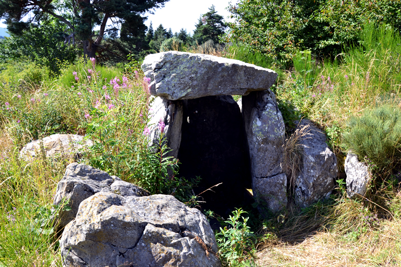
- At the crossways ""Le Dolmen", carry on straight ahead towards "Le Dolmen (site, 0.3 km)". After a short walk uphill, you will reach a flat with a beautiful view on the Eysse Valley.
- The dolmen is on your left, 100 m away, at the end of the field. Once there, retrace your steps to the Echamps hamlet.
- Back to the Echamps crossroads, take the road straight ahead towards "Tour du rocher de Pialoux, 2.2 km - Borée, 2.4 km".
- At the fountain, turn left and immediatly right on the path going uphill up to the road.
- Cross it in the direction of "Serre Chanéac" and follow the path going slightly to the right. Follow the road and the white and yellow markings. After a while in the forest, the path opens with beautiful sights on the Boutières.
- At the Prêle crossways, at the pass, turn left on the path going downhill towards "Borée, 1.4 km". You are now in front of Mont Mézenc and the Boutières Cirque. After a while on the edge of the forest, the path goes into the woods. Stay on this main path going downhill, straight ahead.
- Once on the road, take it on the left up to the Fin gras statue, then carry on straight ahead towards Borée and its main square, your starting point.
- Departure : In Borée, from the main square, at the hike pole marker.
- Arrival : In Borée, on the main square, at the hike pole marker
- Towns crossed : BOREE
Forecast
Altimetric profile
Sensitive areas
Along your trek, you will go through sensitive areas related to the presence of a specific species or environment. In these areas, an appropriate behaviour allows to contribute to their preservation. For detailed information, specific forms are accessible for each area.
Natura 2000 Secteurs des sucs Gerbier et Mézenc
Natura 2000 est une politique Européenne dont l'objectif est de préserver la biodiversité à l'échelle de l'Europe. Avec ses presque 30 000 sites reconnus, il est aujourd'hui le plus grand réseau de sites naturels au monde. Le site que vous traversez à pour but de préserver les landes du Mézenc qui abritent une faune et une flore rare à l’échelle Européenne.
Merci de bien vouloir rester sur les sentiers aménager afin de ne pas déranger la faune ni piétiner la flore.
Merci de bien vouloir rester sur les sentiers aménager afin de ne pas déranger la faune ni piétiner la flore.
- Impacted practices:
- All practices
- Contact:
Recommandations
Randonnée facile en dehors de quelques montées un peu raides.
Access and parking
From Mont Mézenc, take the road D378 in the direction of Borée.
From Saint-Martial, take the road D377
From Saint-Martial, take the road D377
Parking :
Parking en face de la mairie
Report a problem or an error
If you have found an error on this page or if you have noticed any problems during your hike, please report them to us here: