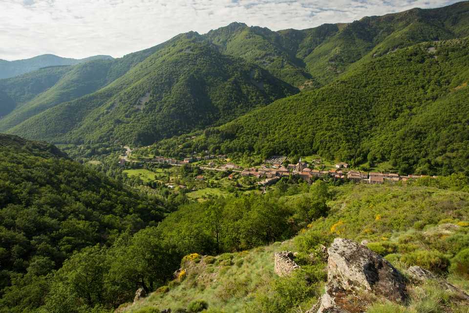
Abraham rock, Mayres
Mayres is a village in the Ardèche valley, at the entrance of the Ardèche mountain. You will traverse preserved paths. During this walk you will begin by following the « Trail de la Chaussée des Géants » run to continue your ascent toward the Abraham rock. (Ancient occitan name : Abran, which means steep). You will then stride along a ridge path. It is a beautiful walk for experienced walkers.
Description
Departure point from the hikes info board at the church square.
 Follow the « Col d’Abraham/La Souche » panel. When you passed the cemetery, take the path that goes up in the chestnut grove. Take the footbridge that permits to cross the Passadou stream.
- You are at the Passadou : Follow the « Col d’Abraham 2.7km/ La Souche » panel. Continue to climb up in the beech wood where you can observe the Eagle Rock. Cross the path and clim up to the col.
- You are at Abraham col : Follow the « Rocher de Taillades 4.7km/Mayres » panel. Walk along the track on the right, once used by the forester. Be careful on your way, go higher than the do-not-enter sign on the permanent route of the « Trail de la Chaussée des géants » run.
- To reach the Abraham rock summit (1498m), leave the guards path and take left the 3 yellow points sign track. Careful, the way is rocky and craggy. Not recommended to the beginners. There is a beautiful 360 degree view as well as a metal sculpture made by P.F Chipon that beared the effigy og Jean Gilly, important sportsman of Ardèche and defender of activities of nature and of Ardèche mounts. Otherwise, continue the guards track on mountain side to Mendras col.
- You are at Mendras col. Take the ridges path on the right.
- You are at Fautouras : Follow the « Rocher des Taillades 2km / Mayres 9.1km » panel. Follow the markings on the ridges path. At Poignets tower, there is a magnificient panoramic view on the Lozere and Tanargue mounts and the Rhône valley. By clear weather, you can see the Ventoux and Gerbier de Jonc Mounts, the Mézenc and the White Mount.
- You are à Taillades Rock : follow the « Mayres par la Cesse 7.1 km » panel. Fast slope through the beech wood by following the snaking path to the Passadou stream.
- You are at the Passadou, follow the « Mayres 2.3km » panel. By the same path you will reach the church square.
For the longer alternative path take the « Mayres par le bois de Pergeyres 8.4km » panel at the Taillades rock.
In Cautet follow the « Mayres » panel that follows the Ardèche then go down through the beech wood. Cross Mayres village to reach the starting point. It is 45 minutes additional.
- Departure : Church square
- Arrival : Church square
- Towns crossed : MAYRES and LA SOUCHE
Forecast
Altimetric profile
Sensitive areas
Natura 2000 Massif du Tanargue, sources de l’Ardèche et de la Borne
- Impacted practices:
- All practices
- Contact:
Recommandations
Information desks
Tourism Office
2 place du Bosquet, Neyrac les Bains, 07380 Meyras
Access and parking
Parking :
Report a problem or an error
If you have found an error on this page or if you have noticed any problems during your hike, please report them to us here: